 Skip to main content

What is S-102?
As part of the emerging S-100 data framework being introduced by the International Hydrographic Organization (IHO), S-102 is the new standard for bathymetric surface. This data set contains high-resolution profiles of the seafloor that can be overlaid onto next-generation S-101 Electronic Navigational Charts (ENCs).
S-102 uses highly detailed data from hydrographic surveys to provide a much more granular view on the shape and nature of the seafloor. This can support more precise navigational decision making, particularly in highly congested or shallow waterways such as port approaches.
Contours vs bathymetric surface
When Electronic Navigational Charts (ENCs) were first introduced, information was transferred from existing paper chart coverage. This included the use of contour lines to indicate depth, which are typically displayed at intervals of 5m, 10m or 20m.
When using Electronic Chart Display and Information Systems (ECDIS), mariners set a ‘safety contour’ based on their vessel’s draught so that the system can delineate safe areas for navigation. However, the ECDIS is limited to the predefined contour intervals on the ENC (usually 5m, 10m or 20m). Therefore, if a mariner sets a 11m safety contour for an 11m draught vessel, often the ECDIS will default to the nearest 20m contour – excluding 9m of safe water and restricting the navigable space available. If the mariner then crosses the safety contour, this will cause an alarm to sound.
Although some high-density ENC coverage is available – with smaller contours of 0.5m or 1m – ENCs are still fundamentally reliant on standardised contours. In contrast, S-102 bathymetric surface data provides a much richer picture of the shape and nature of the seafloor.
This data can be overlaid on top of an S-101 ENC to enable users to set a much more precise safety contour based on the true depth of water underneath the keel. This could open up more navigable space, including areas which would have previously been considered out of bounds with traditional ENCs (where the ECDIS would have defaulted to the nearest contour).
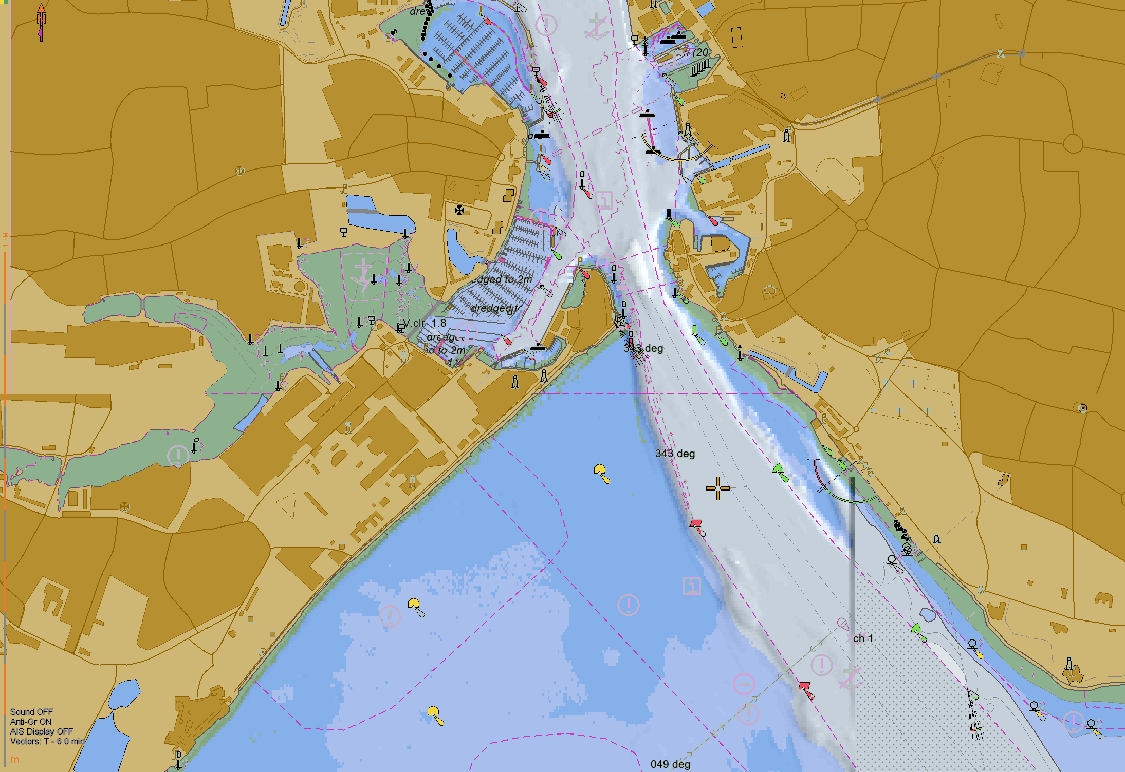
S-102 data overlaid onto an S-101 ENC (Credit: OSI)
What are the benefits of S-102?
Having a more granular and accurate view of the seafloor can not only aid navigational precision, but also support more efficient operations for shipping companies and ports.
More efficient cargo loading
With greater confidence of the true depth of water underneath the keel, vessels may be able to load additional cargo, resulting in more efficient voyages. In a recent report from Thetius, calculations suggest that for every additional 10cm of under-keel clearance available, an average 400m vessel could load 100 additional TEU, meaning greater economic efficiencies and revenue.
Interoperable with other data sets
S-102 data has been developed using the same standardised, gridded format as other product specifications in the S-100 data framework. This means S-102 will be fully interoperable with a range of other powerful marine data sets for use at sea or on shore – for example, mariners will be able to toggle between their S-101 ENC and more granular S-102 data as required.
Dynamic under keel clearance calculations
Integrating S-102 bathymetry with water levels information (S-104) will allow for dynamic adjustment of under keel clearance calculations in near real time, meaning the safety contour can autonomically adjust in line with the changing tides. In a port environment, this could extend the tidal window for vessels entering or exiting port, improving operational efficiency and reducing the need for anchorage fees.
Fit for the future
Thanks to the standardised, gridded format of the S-100 data framework, S-102 – and other data sets alike – will evolve and continue to be compatible as navigational technology advances. For example, S-100 data sets are being developed to be machine-readable in line with requirements for emerging automated and autonomous technologies.
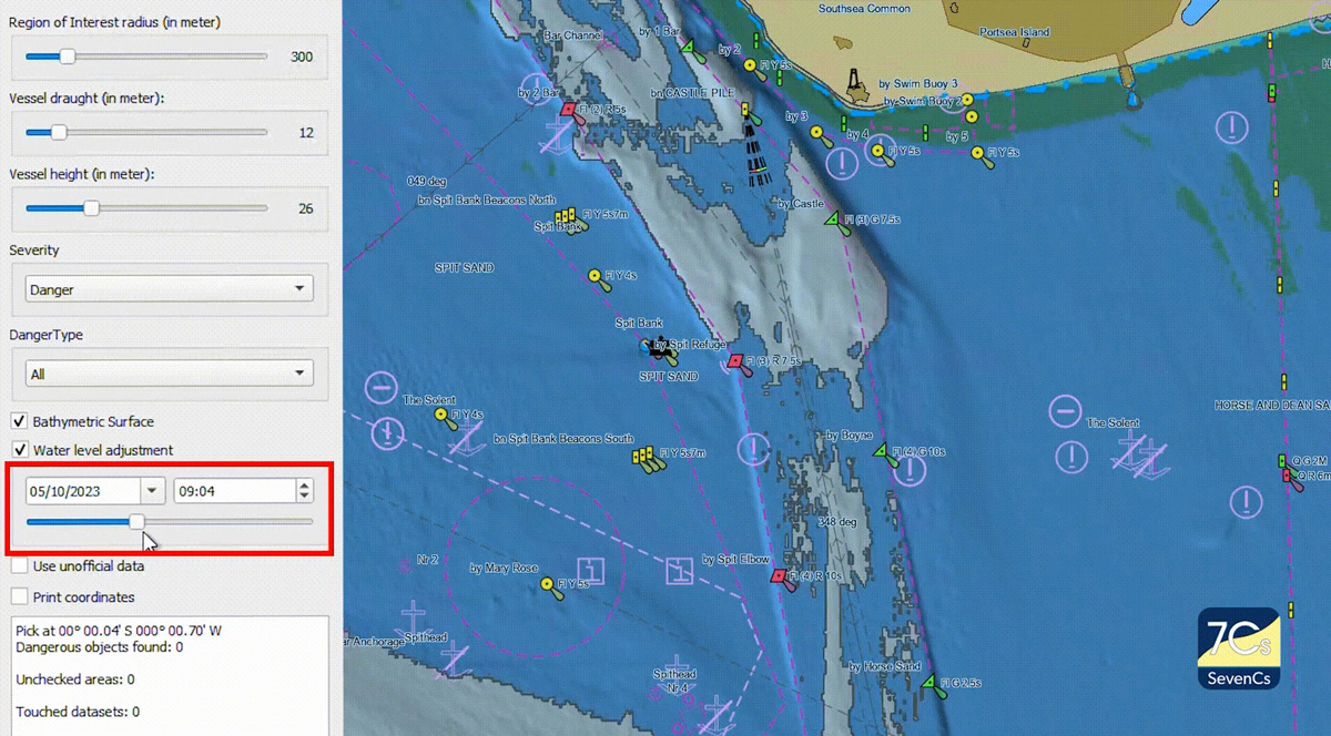
An example of dynamic adjustments using S-102 and S-104 data (Credit: SevenCs)
Where will S-102 coverage be available?

The development of S-102 is dependent on having sufficiently high-resolution source data. This data comes from hydrographic surveys that use multibeam echosounders to capture rich bathymetric data of the seafloor.
Such surveys are most frequently undertaken in high-traffic areas such as port approaches or narrow channels, where more precise navigational data is needed to support safe and efficient operations. Due to the restricted navigable space, these areas are where vessels are most likely to benefit from using bathymetric surface data as opposed to traditional contours. Therefore it is likely that the first coverage and operational use of S-102 data will be in major ports and coastal areas.
In deep ocean areas, where vessels have ample under-keel clearance, there is less need for precise bathymetric surface data and traditional ENC contours are usually sufficient for safe navigation. As a result, it is unlikely that there will be a requirement for global coverage and instead the most navigationally complex areas will be prioritised.
What’s next for navigation?
Watch our webinar to explore how S-100, including S-102, could shape the future of navigation and support safer, more efficient operations.

Name
Thomas Mellor
As Head of Technical Partnerships, Tom leads the UKHO’s collaboration with technical partners including Original Equipment Manufacturers (OEMs) to enable the development of e-navigation products and S-100 solutions for Electronic Chart and Information Display Systems (ECDIS).
Tom works at the forefront of the latest ‘next generation’ navigation technologies to support the implementation of new standards that can help improve safety, efficiency and optimisation.
Learn more about S-100
Discover how the S-100 data standards could transform decision making from ship to shore.
S-100: Shaping the future of navigation
Discover how the next generation of data standards will transform the way decisions are made from ship to shore.
Subscribe to keep updated on S-100
Subscribe to keep updated on the latest developments of S-100 data standards and how these are shaping the future of navigation.