 Skip to main content

The UK Hydrographic Office (UKHO) produces the official navigational products on behalf of over 70 nations and, as Primary Charting Authority, fulfils the charting responsibilities for 63 coastal states. These coastal states include small island states in the Caribbean, Indian Ocean, Mediterranean, Southwest Pacific and South Atlantic.
The UKHO works closely with these nations, assisting them in their Safety of Life at Sea obligations and supporting them in sustainable marine environment management — from producing and distributing official navigation products to providing technical assistance, training and expert advice.
Working with the wider marine community, the UKHO is committed to ensuring these nations have a clear view of the seabed within their marine estate. Collecting and sharing accurate and up-to-date seabed mapping data not only supports the safety of navigation in their waters but is also critical to these nations' blue economies, as many depend on the ocean for work, tourism and leisure.
How seabed mapping data can support management of the marine environment
Known as the 'Emerald Isle of the Caribbean', Montserrat is a British Overseas Territory with around 4,400 residents. The UKHO has been supporting the Government of Montserrat through the Overseas Territories Seabed Mapping Programme (OTSMP) to develop its hydrographic understanding and capabilities; this is critical to supporting sustainable economic growth, ensuring safe maritime operations and helping to protect communities from climate change impacts.
Funded by the UK's Integrated Security Fund, our experts have been working alongside the Montserrat Hydrographic Survey team to collect data from the waters around the island. The work aims to improve the safety of navigation and help the local government to understand, manage and protect the territory's vital ecosystems.

During the summer of 2022, the UKHO and the Royal Navy (RN)collected hydrographic data in the waters around the island with the assistance of the Montserrat Hydrographic Survey team. This data supports disaster resilience, habitat mapping and a wide range of projects within the marine space, enabling informed decision-making. The data is also available to the RN to assist with relief planning, a crucial task given the continuous volcanic activity of Montserrat's Soufrière Hills.
The UKHO has also been working with the Government of Monserrat on hydrographic governance, culminating in the production and review of its Hydrographic Action Plan. Our Hydrographic Programmes team helped to install a Marine Environmental Monitoring Station in Little Bay to collect tidal data critical to refining the modelling and prediction of tides. The station's information is available on the Intergovernmental Oceanographic Commission's website. It also links to regional Early Warning and Migration Systems for tsunamis.
Why is seabed mapping important?
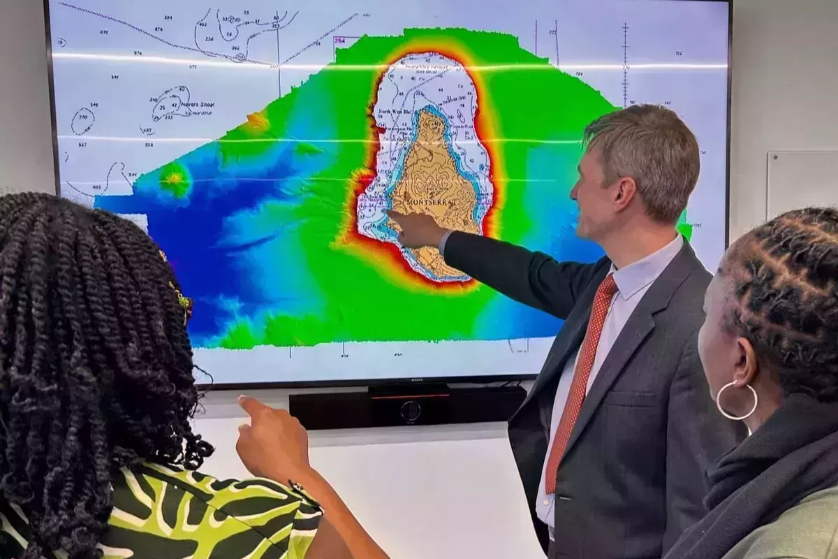
During a recent visit to the UKHO headquarters in Taunton to attend an OTSMP Hydrographic Governance training workshop, Lavern Ryan, Geospatial Information Specialist Manager, and Nicole Duberry, Chief Surveyor for Montserrat, received the latest validated hydrographic data set from Montserrat's nearby waters.
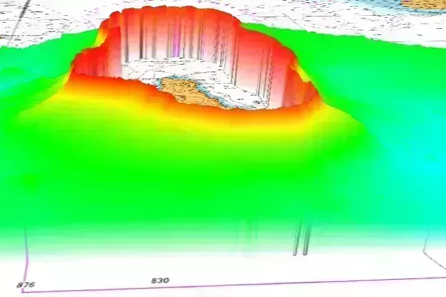
Collected by HMS Protector, a Royal Navy ship, the dataset covering 1,155 km2 will enhance other seabed mapping data collected around Montserrat by the UKHO and the Montserrat Hydrographic team in recent years.
The new dataset shows the rapid change in seabed contouring and features from around 150m and deeper away from the island for the first time, directly supporting Montserrat's ambitions to understand, protect and utilise its marine environment, informing future marine development work. This work is a direct and tangible example of the power of marine data – and of how working with island territories like Montserrat can have a lasting, positive impact on economies and livelihoods worldwide.
Hear from our partners at the OTSMP workshop
The OTSMP exists to improve the safety of navigation through hydrography and developing hydrographic capability.